
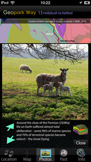
The app guides your walk along the Hollybush to Ketford section of the Abberley and Malvern Hills Geopark Way – a 109 mile walk running between Bridgnorth in Shropshire England to Gloucester Cathedral. The trail is divided into 17 sections, with an app for each section. This section of the trail covers the greatest range of rock ages and types, from Precambrian metamorphic rocks to Triassic sandstones. The path starts at the Hollybush car park, climbing around the base of Ragged Stone Hill, to reach Cambrian and Ordovician shales with dolerite intrusions. From there the path climbs to the summit of Chase End Hill will all round stunning views. As you descend you pass a quarry exposing pegmatites, onto Permian and Triassic desert sediments, with exposure of fossil sand dunes. The path passes through the attractive village of Bromsberrow, on through extensive areas of crop growth, up a sandy hill, through a wood and down to the hamlet of Kinlet by the River Leadon.The app has 5 core views, the default is the Map of the trail, overlain on a geology map derived from the British Geological Survey DiGMapGB-50 (1:50,000 scale) data for the Hollybush to Ketford area. You have this map built into the app, along with all the associated BGS data, which is then always available as you walk, served to your position by GPS or, by simply touching the map if using the app away from the area, or on a device without GPS. The map can be zoomed to x4.The Photos view contains a series of pictures taken along the walk, from the perspective of someone walking in either direction – you select which direction to view. When you use the app in the area, images and information relevant to your location are served to you. You can also virtually walk the path – perhaps to get a feel in advance of how challenging the terrain will be. Linked to the Photos view are 3D sections of the geology and reconstructions of ancient environments.The Location view provides position data and optionally will record your walk and provide an updated estimate of how long to it will take you to complete. The Past view places the rocks under you, into their global tectonic setting, of plate positions along with data for past CO2, oxygen, temperature, sea level and species extinction rate. Recreations of possible ancient landscapes of the GeoPark are provided, together with maps of past landmasses and oceans such as the Iapetus, Rheic and Tethys. The Information view provides links to the organisations, including the Herefordshire and Worcestershire Earth Heritage Trust, who founded and continue to promote and manage the Geopark and the trail.The app has all required data loaded and does not require cellular or WiFi connectivity in the field – just a charged battery.


免費玩Hollybush APP玩免費
免費玩Hollybush App
Hollybush APP LOGO

Hollybush APP QRCode
| 熱門國家 | 系統支援 | 版本 | 費用 | APP評分 | 上架日期 | 更新日期 |
|---|---|---|---|---|---|---|
| 未知 | iOS App Store | 1.0 App下載 | $1.99 | 2013-09-11 | 2015-06-04 |