I started writing this application as something that would be useful to me. Since that it has grown and I am rather pleased with it. It is an aid to marine navigation and must be used in conjunction with charts that are printed on that white stuff that is called (So I’m told) paper.
Features
•Designed by and for a sailor. You may find that some of the layouts look “big and blobby” at first sight, but they work at sea. Fiddly and fussy layouts do not.
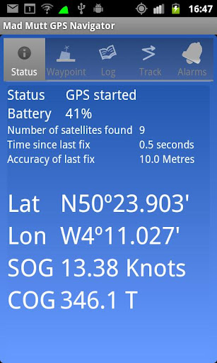
•No network required. This app uses your phone’s GPS, it will work where there is no mobile network coverage (though you will need network coverage to share your logs and waypoints by email).
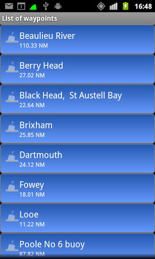
•Store unlimited waypoints (restricted in free version).
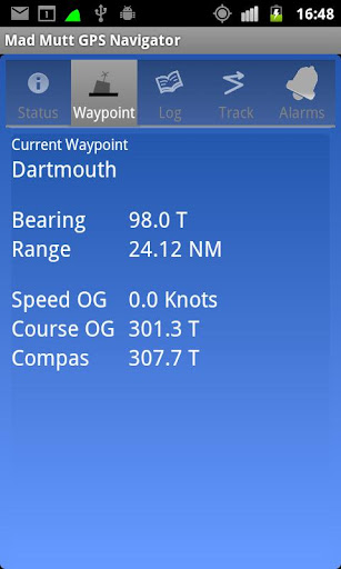
•View waypoints alphabetically of by distance from your current position.
•Display range and bearing to a waypoint.
•Make logs of where you have been, which you can annotate with comments and other relevant data.
•View logs as display on the phone.
•Share logs with Google Earth on your phone or desktop computer, either by email or by copying KML files.
•Share waypoints with Google Earth on your phone or desktop computer, either by email or by copying KML files.
•Share logs with Google Earth on your phone or desktop computer, either by email or by copying KML files. Although I don’t encourage the use of Google Earth for marine navigation, seeing your waypoints on Google Earth is a useful visual check that you have transcribed them correctly.
•Anchor watch alarm service. Alerts you if you have moved more than a pre-defined distance. The anchor watch also alerts you if the battery level is low.
•Near waypoint alarm service
•Once started, the log, anchor and waypoint alarm services will continue to run, even if you quit the main navigator application. They will continue to run while you make phone calls or use your phone for email, Internet browsing or pretty much anything else.
What this application is not
It is not a chart plotter. This application is intended for marine navigation. Although it could be used by ramblers, that isn’t the main intention. It does not display digitised charts, nor does it show you a Google Map view with your position displayed on it. I believe it is highly irresponsible to encourage the use of Google maps to navigate boats. Even in rivers and estuaries, Google maps contain no semantics for the sea whatsoever; no lights and marks, depths, rocks etc. The application does allow you to send logs you have made to Google Maps, though, but only after you have completed the trip.
Free Version
For a limited time, a free version is available. In the Autumn of 2012 a full feature version should be available.
The free version has the following limitations:
•The number of waypoints you can have is restricted to 20.
•Routes are not available
免費玩Mad Mutt Marine GPS Navigator APP玩免費
免費玩Mad Mutt Marine GPS Navigator App
Mad Mutt Marine GPS Navigator APP LOGO

Mad Mutt Marine GPS Navigator APP QRCode
| 熱門國家 | 系統支援 | 版本 | 費用 | APP評分 | 上架日期 | 更新日期 |
|---|---|---|---|---|---|---|
| 未知 | Android Google Play | 1.07 App下載 | 免費 | 1970-01-01 | 2015-04-24 |