Designed by and for a sailor.
This app replicates many of the functions of a hand-held GPS, but with many additional features. The free version of this app has been very well received. The full version incorporates many suggestions that have been made to me. If you already know the free version of this app, skip the introduction to see what the full feature version does in addition to the free version.
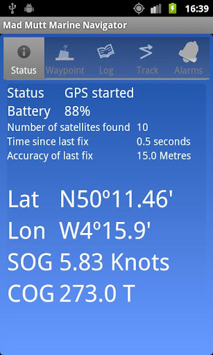
No mobile network is required. This app uses your phone’s GPS, it will work where there is no network coverage (though you will need network coverage to share your logs and waypoints by email).
What this application is not
It is not a chart plotter. This application is intended for marine navigation. Although it could be used by ramblers, that isn't the main intention. It does not display digitised charts, nor does it show you a Google Map view with your position displayed on it. I believe it is highly irresponsible to encourage the use of Google maps to navigate boats. Even in rivers and estuaries, Google maps contain no semantics for the sea whatsoever; no lights and marks, depths, rocks etc. The application does allow you to send logs you have made to Google Earth, though, but only after you have completed the voyage.
Full Version
The full version of this App is now available for a nominal amount. The enhancements include:
•The anchor alarm can now send texts to a second phone, notifying you that your boat may me moving. You can also send a text to the app, if the anchor alarm is set, and receive a reply telling you the position of your boat and how far it has moved. If you switch this feature on, you are given a loud and clear warning, as texts can cost money. There is no in-app billing or anything like that.
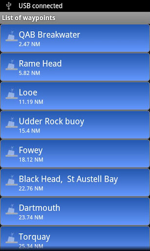
•The number of waypoints you can have is not-restricted.
•Routes are included. Routes are made of many waypoints, and the waypoint alarm can advance you to the next waypoint in a route.
•Waypoints can have notes, and the waypoints complete with notes can be shared with Google Earth.
•ETA to waypoint and VMG to waypoint are now available.
•Engine hours are added to the log service. If you are a sailing boat, just check a box while your engine is running end engine hours are recorded.
•Cross-track error estimate now available.
•Crew on watch and total hours logged on watch can be recorded.
•The log service has a pause facility.
•A barometer monitoring service is available for phones that support a barometer sensor (not many phones do). You can view barometer readings recorded for the last three days, and the barometer service continued to run if you leave the app..
•Limited text to speech on the "Waypoints" view. Course over ground, speed over ground, course to waypoint and cross track error can be spoken.
Other Features
•Designed by and for a sailor. You may find that some of the layouts look “big and blobby” at first sight, but they work at sea. Fiddly and fussy layouts do not.
•View waypoints alphabetically of by distance from your current position.
•Display range and bearing to a waypoint.
•Make logs of where you have been, which you can annotate with comments and other relevant data.
•View logs as display on the phone.
•Share logs with Google Earth on your phone or desktop computer, either by email or by copying KML files.
•Share waypoints with Google Earth on your phone or desktop computer as KML documents
•Share logs with Google Earth on your phone or desktop computer, either as KML (Google Earth) or HTML (any web browser). Although I don’t encourage the use of Google Earth for marine navigation, seeing your voyage on Google Earth an interesting visual record.
•Anchor watch alarm service. Alerts you if you have moved more than a pre-defined distance. The anchor watch also alerts you if the battery level is low.

•Near waypoint alarm service
•Once started, the log, anchor and waypoint alarm services will continue to run, even if you quit the main navigator application.

免費玩Mad Mutt Marine Navigator full APP玩免費
免費玩Mad Mutt Marine Navigator full App
Mad Mutt Marine Navigator full APP LOGO

Mad Mutt Marine Navigator full APP QRCode
| 熱門國家 | 系統支援 | 版本 | 費用 | APP評分 | 上架日期 | 更新日期 |
|---|---|---|---|---|---|---|
| 未知 | Android Google Play | 1.25 App下載 | GBP$2.5 | 1970-01-01 | 2015-04-21 |