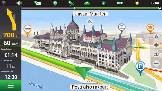
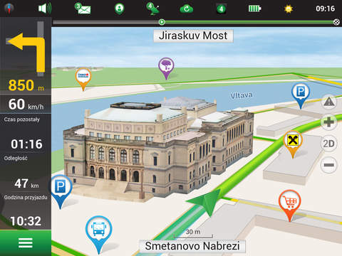
Navitel Navigator is a precise offline navigation with free geosocial services and detailed maps of 59 countries. Try popular navigation for 7 days free!______________________________* 20M DOWNLOADS WORLDWIDE ** TOP 5 NAVIGATION IN 12 COUNTRIES!*______________________________People say:“- From the plenty of navigation apps I tried, this is one of the best.” “- Eger iyi bir navigasyon arıyorsanız iyi bir navigasyon buldunuz.”“- Ottimo insuperabile in galleria ed in uscita dalla stessa molto dettagliato.”“- Buena cantidad de mapas.”______________________________Indian navigation map for Navitel Navigator includes plans of residential and industrial areas of cities, towns and other settlements of India, as well as an extended POI database (petrol stations, car service stations, cafes, restaurants, hotels, chemists', etc.) and information on location of speed cameras (SPEEDCAM).ADVANTAGES• Offline navigation. No Internet connection required for the use of the program and maps: No additional expenses on roaming or dependency on mobile connection.• Offline maps of 59 countries are available for purchase.• Map subscription: Map purchase for a limited period (4 weeks, 1 year) with prices starting at 0.89 EUR.SPECIAL FEATURES• Navitel.Traffic. Information on all traffic jams in the covered area, available in real time.• Navitel.Friends/Cloud. Messaging with friends, tracking their location and routing towards them. Program settings and waypoints are stored in the NAVITEL cloud storage. Log in to Navitel.Friends/Cloud service using your social network profile (Facebook, Twitter, VKontakte)• Navitel.Weather. Weather forecast information for the next three days anywhere in the world.• Dynamic POI. Fuel prices, movie showtimes and other useful information. • Navitel.Events. Road accidents, road works, speed cams and other events marked on the map by users.• Navitel.SMS. Message exchange with friends while navigating.• SpeedCam warnings. Information on radars, video recording cameras and speed bumps.• 3D Mapping. Three-dimensional maps with texture and number of floors support. • 3D Road interchanges. Displaying multilevel road interchanges in 3D mode.• Line Assist. Route calculations taking multilane traffic into account and visual prompts while following the route.• Multilanguage support. Support of the interface and voice prompts in multiple languages.• Turn-by-turn voice guidance. Voice guidance while moving along the route, warnings on battery charge and connection to the satellites. • Dashboard. More than 100 different gauges: time, speed, weather and other parameters.• Fast route calculation. Instant calculation and routing of any length and complexity.• Unlimited number of waypoints for routing. Easy routing with unlimited number of waypoints.• Customizable user interface. Ability to adapt the program interface and map display mode for your own needs.• Multitouch support. • Purchase through the program menu. OFFLINE NAVIGATION MAPS FOR PURCHASE Albania, Andorra, Armenia, Austria, Azerbaijan, Belarus, Belgium, Bosnia and Herzegovina, Brazil, Bulgaria, Croatia, Cyprus, Czech Republic, Denmark, Estonia, Finland, France, Georgia, Germany, Gibraltar, Greece, Hungary, Iceland, Isle of Man, Italy, Iran, Kazakhstan, Kyrgyzstan, Latvia, Liechtenstein, Lithuania, Luxembourg, Macedonia, Maldives, Malta, Mexico, Moldova, Monaco, Montenegro, Netherlands, Norway, Poland, Portugal, Philippines, Romania, Russia, San Marino, Serbia, Slovakia, Slovenia, Spain, Sweden, Switzerland, Tajikistan, Turkey, Ukraine, United Kingdom, Uzbekistan, Vatican.If you have any questions contact us: support@navitel.cz. We will be happy to help you.CONNECT WITH USFacebook: http://www.facebook.com/NavitelWorldTwitter: https://twitter.com/NavitelNInstagram: http://instagram.com/navitel_enContinued use of GPS running in the background can dramatically decrease battery life.

免費玩Navitel & MapMyIndia – India GPS & Map APP玩免費
免費玩Navitel & MapMyIndia – India GPS & Map App
Navitel & MapMyIndia – India GPS & Map APP LOGO

Navitel & MapMyIndia – India GPS & Map APP QRCode
| 熱門國家 | 系統支援 | 版本 | 費用 | APP評分 | 上架日期 | 更新日期 |
|---|---|---|---|---|---|---|
| 未知 | iOS App Store | 9.5.399 App下載 | 免費 | 2015-03-27 | 2015-06-03 |