Offline Map, vector map, totally offline maps, no internet connection.
Key features:
* Offline map
* Store and load map data from memory card
* ZoomIn/ZoomOut/Pan, Pinch to zoom, Long press to open context menu
* Search street by name and/or intersection with other streets
* Search point by name, type, distance or type+name, type+distance
* Search GPS location by latitude and longitude in decimal format
* Partial name search
* Can touch any object on map (point, street, building, park, river...) to view its name
* Text to Speech point/street name in 5 default languages: German, English, Spanish, French, Italian. If you use other TTS, it can speak point/street name in more than 20+ languages.
* GPS real-time tracking with built-in compass
* Rotate map
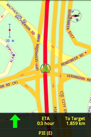
* Voice guidance
* Navigation with Routing offline from point to point.
* Supports all android phones and tablets screen sizes and densities. You only need to purchase the application one time, Android Market allows you to install and use this application on all android devices that you have (android phones + 7", 9" or 10" android tablets) without any additional charge.
If you want to try the application to see how it works, you can download demo versions:
* Denver (USA) Offline Map https://market.android.com/details?id=denver.digitalmobilemap.com
* Singapore Offline Map https://market.android.com/details?id=singapore.digitalmobilemap.com
For quick use of the application, use PC/laptop to download offline map data files for following cities from http://www.mediafire.com/?6i729cajchy5s then put the .jar files in your android memory card before purchase the application and use the application to open the .jar files.
Amsterdam.jar
Bangkok.jar
Berlin.jar
Brussels.jar
Bucharest.jar
Budapest.jar
Chennai.jar
Denver.jar
Jerusalem.jar
LasVegas.jar
London.jar
LosAngeles.jar
Madrid.jar
Manchester.jar
Monaco.jar
Moscow.jar
NewYork.jar
Paris.jar
Rome.jar
Saopaulo.jar
Sydney.jar
Tokyo.jar
...
To generate map data for other city/country, follow instructions from:
http://www.digitalmobilemap.com/download
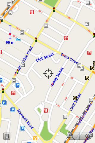
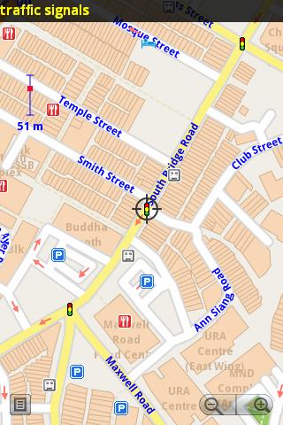
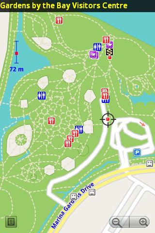
Screenshots:
http://www.digitalmobilemap.com/screenshots
Basic User Guide
Touch and drag to move map, pinch to zooom, tap on + button to zoom in, tap on - button to zoom out, tap on an object (street or point) to view its name, double tap or touch and hold (long press) on an object (street or point) to set that object as start waypoint or target waypoint.
There is an option to load routing nodes into memory. Select this option to speed up calculation of shortest/fastest route.
How to use turn by turn navigation:
1. Define start waypoint and target waypoint then select AutoRouting from main menu to calculate shortest/fastest route. The application will remember your route.
2. Turn on "In Car Navigation When GPS Tracking/Routing" and "Keep On Road When Tracking" options in Setup menu
3. Select GPS tracking from main menu.
4. Wait until the application receive the first GPS signal. (It may take a few minutes to get GPS fix depend on your phone GPS receiver).
5. Mount your phone on the phone handle in your car.
6. Drive along the shortest/fastest route highlight on the map, the application will speak to you with voice guidance (turn left or turn right).
7. Follow the turn by turn navigation instructions you will reach the target waypoint.
Disclaimer:
Map data is from OpenStreetmap (http://www.openstreetmap.org) and contributors under a Creative Commons Attribution/Share Alike License (http://creativecommons.org/licenses/by-sa/2.0/).
OpenStreetMap is a collaborative, wiki-like mapping project. Because of openly-editable wiki nature of the OpenStreetMap, map data is subjected to mapping errors. The application will able to find correct shortest/fastest route most of the times, however we can not guarantee the application is ALWAYS able to find correct shortest/fastest route with OpenStreetMap data.
免費玩Offline Map APP玩免費
免費玩Offline Map App
Offline Map APP LOGO

Offline Map APP QRCode
| 熱門國家 | 系統支援 | 版本 | 費用 | APP評分 | 上架日期 | 更新日期 |
|---|---|---|---|---|---|---|
| 未知 | Android Google Play | 8.2 App下載 | SGD$2.99 | 1970-01-01 | 2015-03-09 | |
| 台灣 Taiwan | Android Google Play | 8.2 App下載 | NT$70.0 | 2012-08-28 | 2015-03-27 |