
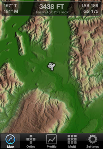
FSWidgets SimTAWS is a cloud based Terrain Awareness and Warning System for use with the popular flight simulators FSX, FS2004, X-Plane 10 and X-Plane 9. Terrain collision alerts, visual and audible, right in the palm of your hand! Powered by the FSWidgets Terrain Rendering engine, this app delivers enhanced situational awareness for the sim pilot. When connected to the desktop flight simulator, the color coded terrain changes according to relative aircraft altitude and terrain altitude, warning the pilot when terrain is ahead or descent rates are uncontrolled. SimTAWS will guide the simulator pilot safely under many conditions including: 1. General aviation night flight 2. Low visibility takeoff and landing due to inclement weather conditions 3. Unfamiliar flight plans through mountaineous terrain 4. Low speed helicopter manoeuvers, search and rescue, evac procedures and drills 5. Instrument flight training and practice Four unique views provide the pilot with: 1. Map View, top down shaded terrain with indicative only altitude colouring 2. Ortho View, top down rendered terrain showing precise terrain colouring changing with aircraft altitude 3. Profile View, side on view showing terrain ahead and collision impact location using green, yellow, red coloring 4. Multi View, combination view showing profile alongside switchable Map and Ortho views Visual indications include: 1. green terrain is greater than 5000 ft below the aircraft 2. yellow terrain is less than 5000 ft below the aircraft 3. red terrain is above the aircraft Audible indicators include: 1. Forward Looking Terrain Avoidance (FLTA) will predict up to 90 seconds ahead of time if collision is imminent2. Excessive rate of descent alerts will sound at or below 2400 ft AGL where descent rates are over 4000 fpm, decreasing linearly to 2000 fpm at 500 ft AGLMain features: 1. Easily connect & disconnect from the flight simulator as required 2. World-wide terrain data access (SRTM, coverage between 60∫N and 60∫S latitude) 3. Support Flight Simulator X, Flight Simulator 2004, X-Plane 10 and X-Plane 9 4. X-Plane supported on Windows, Mac and Linux 5. Track up and North up displays 6. Terrain elevation sampling at 90 meters, well in excess of minimum 200-300 meter aviation requirements 7. Multi-view summary screen to provide "At a Glance" terrain awareness 8. Compass ring and trajectory nose line toggle with a simple button press What do you need: 1. Microsoft Flight Simulator FSX, FS2004, X-Plane 10, X-Plane 9 2. FSWidgets Network Pack 3. Internet connection for near real-time terrain elevation download 4. And of courseÖSimTAWS How does it work: 1. Install the FSWidgets Network Pack available from our site 2. Run your favourite flight simulator on your Windows or Mac or Linux machine 3. Run the Network Pack utility 4. Run SimTAWS 5. That's it, you now have near real-time cloud based terrain warning and avoidance capability Who we are:FSWidgets is a software development team based in Australia, specializing in add-ons for Microsoft Flight Simulator (Windows) and Laminar Research X-Plane (Windows, Mac, Linux). Both of its founding members have extensive experience in creating award-winning add-ons for flight simulators and have been active in the simming community for well over a decade.Support and Update:Future updates and additional features added to FSWidgets SimTAWS will be free for existing customers. Please do let us know if you have thoughts, suggestions, ideas, praise or criticism (be gentle). We'd love to hear from you and we reply to every single email, every time. Come and visit http://fswidgets.com and share your experiences with us.


免費玩SimTAWS APP玩免費
免費玩SimTAWS App
SimTAWS APP LOGO

SimTAWS APP QRCode
| 熱門國家 | 系統支援 | 版本 | 費用 | APP評分 | 上架日期 | 更新日期 |
|---|---|---|---|---|---|---|
| 未知 | iOS App Store | 1.1 App下載 | $14.99 | 2012-07-14 | 2015-06-03 |