
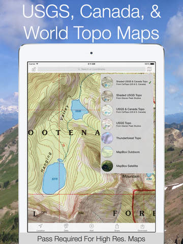
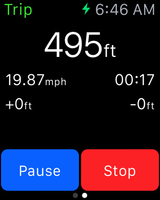
Dream Less, Adventure More! Download Topo maps for offline use while deep in the backcountry. "Topo Maps+ is your best backcountry companion" -- TUAW (The Unofficial Apple Weblog) NEVER GET LOST AGAIN Combine GPS with downloaded USGS, MapBox, NRCAN/GEOBC, and Thunderforest topo maps and you can view you current location on a topo map even when you are at that perfect hidden mountain lake that is days from the nearest the cell tower. Use the GPS and compass on your iPhone to see you current location and to align the map with the direction you are looking. (GPS and compass work without an internet connection.) APPLE WATCH SUPPORTView your offline maps and current location just by glancing down at your wrist. You no longer need to pull your iPhone out of your bag to check your position.DOWNLOAD MAPS Easily download USGS, MapBox, NRCAN/GEOBC, Thunderforest, and Satellite maps so you can use the maps offline while deep in the backcountry. PLAN YOUT NEXT ADVENTURE Be prepared for that awesome journey through majestic mountains, down flower ladened valleys, and over craggy passes. Trace routes to find approximate distances and elevation profiles between locations. After tracing a route on a topo maps you can view that route on the Satellite map. GORGEOUS MAPS * Detailed USGS 7.5 minute topo maps for the USA. USGS topo maps are the ultimate map for hiking, backpacking, mountain biking, and other outdoor activities. They have the details you need while in the backcountry. * Detailed USGS 7.5 minute topo maps with stunning relief shading for the USA. This gorgeous relief shading makes the USGS topo maps much easier to read and use. * NRCAN/GEOBC topo maps for southern and western Canada.* Thunderforest outdoor map has contour lines, trail, and outdoor features for the whole world. * MapBox Outdoor map has world wide hiking and biking trails.* MapBox Terrain is a beautiful elevation and land-use layer for the entire world, visualizing hills and elevation contour lines. * MapBox Satellite offers highly-detailed imagery for the whole world. * MapBox Street map is an ideal map for urban use and getting to the trail head.* New Zealand Topo Maps from LINZ are the ideal maps for exploring New Zealand.PLAN * Download maps for use offline. * Easily trace routes to find approximate distance between locations. * Add waypoints to maps. * Print maps just in case something happens to your iOS device. If you don’t have an airprint printer you can email yourself the map and print it from another computer. * Trace over a trail on a topo map and then visualize that trail with the MapBox terrain and satellite maps. EXPERIENCE * View your current location on the map, even if you are offline. * Use the compass to orientate the map so you know which direction to go. * Record your trip to see your distance, elevation profile, and average speed. * With downloaded maps you can go deeper and farther into the backcountry without being worried about having an internet connection. SHARE, IMPORT, & EXPORT* Share routes, trips, and waypoints with your friends.* Share custom map images* Export routes, trips, and waypoints to KML & GPX files to use in other apps.* Import routes and waypoints from KML or GPX files.TAGS* Organize your routes, trips, and waypoints with beautiful tags.* Share tags with your friends so they can import the data into Topo Maps+ or into another app via a KML or GPX file.CLOUD * Sync your routes, trips, and waypoints between all of your iOS devices. * Sync your map subscriptions between all of your iOS devices.Continued use of GPS running in the background can dramatically decrease battery life.


免費玩Topo Maps+ APP玩免費
免費玩Topo Maps+ App
Topo Maps+ APP LOGO

Topo Maps+ APP QRCode
| 熱門國家 | 系統支援 | 版本 | 費用 | APP評分 | 上架日期 | 更新日期 |
|---|---|---|---|---|---|---|
| 未知 | iOS App Store | 3.2 App下載 | 免費 | 2013-07-30 | 2015-06-03 | |
| 美國 (U.S.A) | iOS App Store | 2.6 App下載 | 免費 | 2014-07-17 | 2014-09-19 |