
Makes your iPhone or WiFi+Cellular iPad into a high-performance GPS receiver with both USGS & US Forest Service topo maps! If you are headed into the wilderness, buy this app now so you will always know where you are, where you've been, and where you're going. You will have the highest quality track recording, the best route navigation, and the most accurate Estimated Time of Arrival of any available hiking app. No sign up, no subscription, no in-app purchase required. Recommended in “Essential Gear for Safe Hiking”.
TRACKS, WAYPOINTS & ROUTES
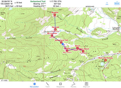
▶ Record a track. View it on the map. Record in the background when using another app or your device is asleep
▶ Show an elevation graph of your track or a route with altitude data. View date, time & average speed of track points
▶ Mark waypoints using a convenient button on the map screen or by tapping a geotagged photo. Refine a waypoint position when you arrive

▶ Set a quick GoTo waypoint or a full route and see the heading, direction, horizontal distance, vertical distance & Estimated Time of Arrival
▶ Import & Export GPX files of waypoints, routes & tracks via AirDrop, eMail, Messages, Dropbox, Open In, or iTunes
▶ Uses GPS+Glonass satellites for improved accuracy in challenging terrain with iPhone 4S, iPad mini, iPad 3 & later
FOREVER-FREE TOPO MAPS
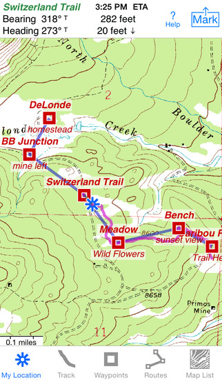
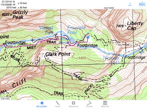
▶ USA: 24K USGS & US Forest Service topo maps. Store both to use anywhere.
▶ Most Forest Service maps were updated since 2011. Prominently displayed Forest Service road numbers make a huge difference for finding your way around the back country
▶ Alberta & British Columbia south of 54° latitude, New Brunswick, Nova Scotia & Prince Edward Island: 50K National Resources Canada topo maps
▶ Stitches beautiful high resolution, detailed topo map images for seamless coverage across map boundaries
▶ Maps from our server have a shorter download time, use less of your monthly data allotment & use less memory on your iOS device

▶ Download using WiFi or cell data. Store up to 500 maps to use anytime in the wilderness without cell service
▶ Print maps overlaid with waypoints, routes & tracks. Share locations & map images using AirDrop, email, Twitter, Facebook, Messages, Photos, or the clipboard.
SET IT UP AS YOU LIKE
▶ Miles, nautical miles or km. Ft or meters

▶ Degrees, Degrees/Minutes, Degrees/Minutes/Seconds or UTM
▶ °True or °Magnetic
HOW TOS
▶ Tap Help in the App
▶ Online Manual on our web site
▶ Follow us on Twitter: @iHikeGPS
▶ Email developer: lwjames@iHikeGPS.com
WHAT OTHERS SAY
▶ “I want to tell you I am VERY impressed!!!…It pretty much blows… , my previous fave GPS app, out of the water. Your track recording features, fast map downloads, and well thought out interface make it a real winner. It's very sophisticated software, and makes my iPhone just about as good as $600 Garmin Montana. Actually better, in a lot of ways”-John in OR

▶ “GREAT APP! I have been using this for a few weeks now and am really loving the interface, the maps, and the features you've provided”-Laurie in TX
▶ “Perfect for anyone camping, fishing and hiking, it'll provide great detail when you need it the most…for anyone who takes the great outdoors seriously”-David on handhelditems.com
▶ “I just wanted to thank you for developing IHIKEGPS and to tell you what a great product it is. I am impressed!…I use it hiking, biking, skiing and Jeeping”-Ammon in CO
DEVICE REQUIREMENTS
● No device requires a cellular data plan to use iHikeGPS
● iPhone 6, 6 Plus, 5s, 5c, 5, 4S, 4 & 3GS & all WiFi+cellular iPads support full navigation
● iPod touch (gen 3 or later) & WiFi-only iPads require an iOS-compatible external GPS receiver to show your location in the wilderness & record tracks. View maps using the iOS device alone
• GPX file sharing via AirDrop & Messages requires iOS 7 or later
● Continued use of GPS running in the background can dramatically decrease battery life

Your dream of hiking adventures reaches new heights with iHikeGPS

免費玩iHikeGPS : USA + SE & SW Canada Topo Maps with Full Navigation APP玩免費
免費玩iHikeGPS : USA + SE & SW Canada Topo Maps with Full Navigation App
iHikeGPS : USA + SE & SW Canada Topo Maps with Full Navigation APP LOGO

iHikeGPS : USA + SE & SW Canada Topo Maps with Full Navigation APP QRCode
| 熱門國家 | 系統支援 | 版本 | 費用 | APP評分 | 上架日期 | 更新日期 |
|---|---|---|---|---|---|---|
| 美國 (U.S.A) | iOS App Store | 4.6 App下載 | $7.99 | 2014-09-11 | 2014-09-24 |